| Region IV-A CALABARZON | |||
|---|---|---|---|
| — Region — | |||
| |||
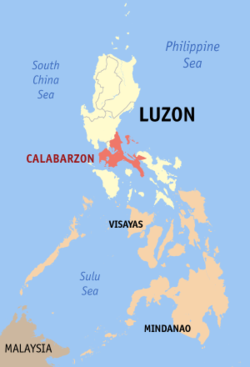
| Map of the Philippines showing the location of Region IV-A | |||
| Country | Philippines | ||
| Island group | Luzon | ||
| Regional center | Calamba City, Laguna | ||
| Area | |||
| – Total | 16,558 km2 (6,393.1 sq mi) | ||
| Population (2007) | |||
| – Total | 11,743,110 | ||
| – Density | 709.2/km2 (1,836.8/sq mi) | ||
| Time zone | PST (UTC+8) | ||
| Provinces | 5 | ||
| Cities | 15 | ||
| Municipalities | 129 | ||
| Barangays | 4,011 | ||
| Cong. districts | 19 | ||
| Languages | Tagalog, English | ||
CALABARZON is one of the regions of the Philippines. It is also designated as Region IV-A and its regional center isCalamba City in Laguna. The region is composed of five provinces, namely: CAvite, LAguna, BAtangas, Rizal, and QueZON; the region's name is formed from the names of these provinces.
The region is in southwestern Luzon, just south and east of Metro Manila and is the second most densely populated region.
CALABARZON and MIMAROPA were previously combined together as Southern Tagalog, until they were separated in 2002.
Executive Order No. 246, dated October 28, 2003, designated Calamba City as the regional center of CALABARZON. The largest city of CALABARZON Region and the second highly-urbanized city is Antipolo City. Lucena City is the first highly-urbanized city in this region. While the largest metropolis in the region is Laguna West Metropolitan.
History
Region IV-A had a very important role in the history of the Philippines. Philippine independence was held by the first Philippine President,Gen. Emilio Aguinaldo, on June 12, 1898.
People from Batangas, Cavite and Laguna were a part of those who first revolted against the Spaniards for freedom. While the Philippines' national hero, Dr. Jose P. Rizal, his brother, Paciano Rizal and Vicente Lim are also born in Calamba City. Apolinario Mabini, born inTanauan City, Batangas
The eight primary rays of the sun found in the Philippine Flag represent the first eight provinces (Batangas, Bulacan, Cavite, Laguna, Manila, Nueva Ecija, Pampanga, and Tarlac) that sought independence from Spain and were placed under martial law by the Spaniards at the start of the Philippine Revolution in 1896.
Political divisions
| Province/City | Capital | Population | Area (km²) | Pop. density (per km²) | |
|---|---|---|---|---|---|
 | Cavite | Trece Martires City | 2,856,765 | 1,287.6 | 1,602.3 |
 | Laguna | Santa Cruz | 2,473,530 | 1,759.7 | 1,117.2 |
 | Batangas | Batangas City | 2,245,869 | 3,165.8 | 601.8 |
 | Rizal | Antipolo City | 1,650,075 | 1,308.9 | 1,304.3 |
 | Quezon | Lucena City | 2,646,510 | 8,842.86 | 186.20 |
| Antipolo City¹ | — | 633,971 | 306.10 | 2,071.12 | |
| Lucena City¹ | — | 387,978 | 83.15 | 2,842 | |
Component cities
- Tayabas City, Quezon
- Cavite City, Cavite
- Dasmariñas City, Cavite
- Tagaytay City, Cavite
- Trece Martires City, Cavite
- Biñan City, Laguna
- Calamba City, Laguna
- Santa Rosa City, Laguna
- San Pablo City, Laguna
- Batangas City, Batangas
- Tanauan City, Batangas
- Lipa City, Batangas
On August 7, 2000, the municipality of Los Baños, Laguna was declared as a "Special Science and Nature City of the Philippines" through Presidential Proclamation No. 349 in recognition of its importance as a center for science and technology, being home to many prestigious educational, environmental and research institutions. This proclamation does not convert the municipality to a city or give it corporate powers that are accorded to other cities.


