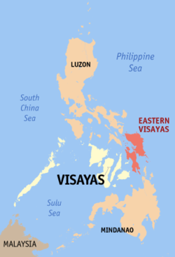
| Region VIII Eastern Visayas | |
|---|---|
| — Region — | |
| Map of the Philippines showing the location of Region VIII | |
| Country | Philippines |
| Island group | Visayas |
| Regional center | Tacloban City |
| Area | |
| - Total | 23,432 km2 (9,047.1 sq mi) |
| Population (2007) | |
| - Total | 3,912,936 |
| - Density | 167/km2 (432.5/sq mi) |
| Time zone | PST (UTC+8) |
| Provinces | 6 |
| Cities | 7 |
| Municipalities | 136 |
| Barangays | 4,390 |
| Cong. districts | 12 |
| Languages | Waray-Waray(Leyte-Samarnon) |
Eastern Visayas is one of the two regions of the Philippines having no land border with another region, MIMAROPA being the other, and is designated as Region VIII. It consists of six provinces and seven cities, namely, Biliran, Eastern Samar, Leyte, Northern Samar,Samar, Southern Leyte, the cities of Ormoc City, Baybay City, Maasin City, Calbayog City, Catbalogan City, Borongan City and the highly-urbanized city of Tacloban, the regional center. These provinces and cities occupy the easternmost islands of Visayas: Samar,Leyte and Biliran.
Eastern Visayas directly faces the Pacific Ocean. The land area of the region is 23,432 km km². As of 2007, it has a population of 3,912,936.
Geography
[edit]Climate
The region belongs to Type-B climate, which is basically wet to very wet with no pronounced dry season. Sometimes during rainy or windy seasons the weather is experiencing least colder, By nightfall the ice fog, mist or haze occurs bringing out the cold in the province.
[edit]Land
Eastern Visayas is primarily an agricultural region with rice, corn, coconut, sugarcane and banana as its major crops. Its total land area is 21,431.7 km². 52% of its total land area are classified as forestland and 48% as alienable and disposable land.
[edit]Natural Resources
The region’s sea and inland waters are rich sources of salt and fresh water fish and other marine products. It is one of the fish exporting regions of the country. There are substantial forest reserves in the interiors of the islands. Its mineral deposits include chromite,uranium(in Samar), gold, silver, manganese, magnesium, bronze, nickel, clay, coal, limestone, pyrite and sand and gravel. It has abundant geothermal energy and water resources to support the needs of medium and heavy industries.
Culture
Languages
Waray-Waray is spoken on the island of Samar, Biliran and the province of Leyte. Cebuano is spoken in the western part of Leyte and Southern Leyte and parts of Biliran and a few island-municipalities in Samar. Both of these languages are called Visayan by their speakers. A Samalanguage, distantly related to the languages of the region, called Abaknon is spoken in the island of Capul in Northern Samar.
Dances
Tinikling, the Philippines' national dance is folkdance that originated from the region. But the most popular cultural dance among Warays is theCuracha, danced during feast celebrations and special gatherings. The Leyte Kalipayan Dance Company, a local cultural group, held highly successful performances around the world.
Music
Waray people are music lovers whose folkloric music are mostly ballads in form, famous of which is "Dandansoy" while "Iroy nga Tuna" (Motherland) is a patriotic song.
Economy
Primary sources of revenue are manufacturing, wholesale and retail trade and services. Mining, farming, fishing and tourism contribute significantly to the economy Manufacturing firms include mining companies, fertilizer plants, sugar central, rice and corn mills and other food processing plants. Tacloban is the hub of investment, trade and development in the region.
Other industries include mining, rice, corn and sugar milling, coconut oil extraction, alcohol distilling, beverage manufacture and forest products. Home industries include hat and basket weaving, metal craft, needlecraft, pottery, ceramics, woodcraft, shell craft and bamboo craft.
[edit]Education
Eastern Visayas is home to several state universities, including the prominent University of the Philippines Visayas (UPV Tacloban College). The region is also home to the University of Eastern Philippines (UEP), located in Catarman, Northern Samar, which holds the most number of baccalaureate and post-baccalaureate courses among universities in the region.
The Zonal Agricultural University for the Visayas under the National Agriculture Education System concept, Visayas State University(VSU) is also in the region, located in Baybay City. Also, the region is home to Palompon Institute of Technology, a maritime school in the Philippines providing deck and engine cadet. Its main campus is located in the municipality of Palompon, Leyte province.
| Province/City | Capital | Population (2007) | Area (km²) | Pop. density (per km²) |
|---|---|---|---|---|
| Biliran | Naval | 140,274 | 555.4 | 252.6 |
| Eastern Samar | Borongan City | 375,822 | 4,339.6 | 86.6 |
| Tacloban City | 1,592,336 | 5,712.8 | 278.7 | |
| Catarman | 500,639 | 3,498.0 | 143.1 | |
| Samar | Catbalogan City | 641,124 | 5,591.0 | 114.7 |
| 360,160 | 1,734.8 | 207.6 |
Highly-Urbanized City
Independent City
Component Cities
 Baybay City, Leyte
- Catbalogan City, Samar
 Maasin City, Southern Leyte
- Borongan City, Eastern Samar
- Calbayog City, Samar


